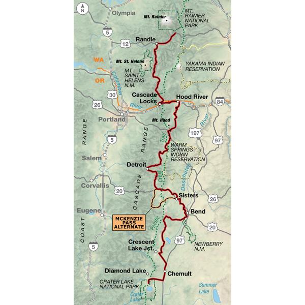
Mt. Rainier NP, WA - Crater Lake NP, OR (452.5 miles)
Product Code
BC-2202
Brand
Adventure Cycling Association
Price
$16.75
Section 2 begins at Mt. Rainier National Park and runs south to the wind surfing country of the Columbia Gorge and Hood River, Oregon. From there it skirts the Three Sisters Mountains near Bend, Oregon and ends in Crater Lake National Park. This section intersects the Lewis & Clark Bicycle Trail in Hood River and the TransAmerica Trail in Sisters, Oregon. The McKenzie Pass Alternate has less traffic, more scenery, and allows cyclists to ride through lava fields at the top of the pass.
Hi All,
This is more a review of the route then the map. The map itself was great and worked out well. However, coming from the south (Diamond Lake) and heading north on Windigo Pass was challenging. We were on loaded road-ish bikes (read: 28 mm, smooth tires). Getting up the gravel road was ok. However, coming down the pass, the road condition deteriorated into effectively sand for the descent. Luckily we made it down ok going about 5 mph and have a good story to tell now. That said, posting here to at least give people a heads up. If you're going to take this route, wider tires - ideally with a little tread - will make life a lot easier if you go the alternate route.
Happy trails,
Mike
Windigo Pass road is in poor shape
Rating:
Reviewed By:
Mike on 7/13/16
Hi All,
This is more a review of the route then the map. The map itself was great and worked out well. However, coming from the south (Diamond Lake) and heading north on Windigo Pass was challenging. We were on loaded road-ish bikes (read: 28 mm, smooth tires). Getting up the gravel road was ok. However, coming down the pass, the road condition deteriorated into effectively sand for the descent. Luckily we made it down ok going about 5 mph and have a good story to tell now. That said, posting here to at least give people a heads up. If you're going to take this route, wider tires - ideally with a little tread - will make life a lot easier if you go the alternate route.
Happy trails,
Mike
A Beautiful route
Rating:
Reviewed By:
A customer from Bouler, CO on 8/24/10
I followed this map only to Bend so it cannot speak for the last couple of sections but up until there it was great. Easy to follow, helpful information for the towns and a very scenic and pretty route.
Sierra Cascades Section 2
Rating:
Reviewed By:
A customer from Corvallis, OR on 7/2/10
Have not set out yet, but plotted the route on the State Bike Routes map to start planning drop off and pick up sites for shuttles etc. Nice to have the routes planned around "cities" and other small places so we can keep off the main drags. If the trip map for the cross country -- Seattle to Bangor -- are as complete, the ride should be a piece of cake -- one peddle at a time for only 93 days!


 based on 4 reviews.