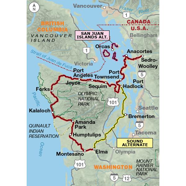
Section 1 of the Washington Parks Bicycle Route begins by heading west out of Sedro-Woolley to Anacortes, with ferry options for riding through several of the San Juan Islands. The route follows the Olympic Discovery Trail from Sequim to Port Angeles, passing the entry to Olympic National Park. The route then heads west to Forks on the peninsula. South of Forks you'll encounter incredible views and ample opportunities to explore the shorelines from the beach parking lots. Elma is where you choose to continue on the main route or connect to the 111-mile Sound Alternate. It is a mostly rural connection back to Port Townsend that includes a spur to the Bremerton ferry, with an option for travel to Seattle.
A great tour - I just did the Olympic peninsula, but the map was missing some things I was looking for about route description (including safety an road quality). Tricky to follow the Olympic Discovery trail (poorly marked and map not detailed enough to help) between Sequim and Port Angeles (which is a great trail)
Mixed feelings
Rating:
Reviewed By:
A customer from Seattle, WA on 8/1/11
Riding from Fort Flager to Port Angeles on the 8 mile stretch of SR 20 between SR 19 and HWY 101 needs to be taken seriously. It is comprised of a single lane in each direction and is a winding, hilly road. The sight lines are minimal and the posted speed limit is 55 mph. Most drivers exceed that limit and drift off into the shoulder on turns. The traffic is constant and includes tractor trailers (double long), transit vans, delivery trucks, and other large vehicles. The shoulder ranged from being several inches wide, several inches wide with a crumbling edge leading to a steep drop off, or crowded by a guard rail forcing a rider into traffic. Unlike, say HWY 101, the SR 20 shoulder was far too narrow for the conditions.
Overall I found the Adventure Cycling descriptions of roads I traveled on along this route to lack sufficient detail to be helpful. YMMV.
The map itself was heavily abused and held up well, the descriptions of services and other information was helpful and appreciated. The map was easy to read/follow and the elevation information was great (although note that scale changes!).
Helpful map but needs some notations
Rating:
Reviewed By:
Gary Clatterbuck on 10/3/09
The state of Washington is in the process of re-surfacing the 101 with a product called "chip-seal", which creates an absolutely horrible surface for us to ride on. WE are using recumbent trikes...and that change is difficult.
PS...one needs to know that wildlife can be dangerous in the region...had a close encounter with a cougar.


 based on 4 reviews.

